
We use cookies to enhance your browsing experience, serve personalized content, and analyze our traffic. By clicking "Accept All" you accept this and consent that we share this information with third parties and that your data may be processed in the USA. For more information, please read our .
You can adjust your preferences at any time. If you deny, we will use only the essential cookies and unfortunately, you will not receive any personalized content.

Two weeks ago, we reported on severe erosion reshaping Reynisfjara Beach near Vík, where persistent easterly winds stripped sand from the shoreline and pushed the Atlantic closer to the basalt cliffs.
New reporting from The Iceland Monitor shows the changes are continuing. Despite mid-February efforts by local landowners to protect the viewing platform and nearby infrastructure, more sand has been lost, access to the lower beach has shifted, and some signage has been removed after being damaged by surf. If you are planning a visit to Iceland’s South Coast, here is what has changed and what it means for travelers right now.
On February 12, The Iceland Monitor reported that landowners at Reynisfjara began actively trying to protect the beach’s infrastructure.
Heavy machinery was brought in to gather basalt rocks that the ocean had thrown inland, some reportedly weighing one to two tons. Those rocks were repositioned and piled beneath the viewing platform to help buffer it from further erosion. The goal was to stabilize the area and prevent additional structural damage.
Landowners also confirmed that new signage and upgraded safety equipment were already in production, funded in part by a service fee introduced in late 2023 to improve safety infrastructure.
At that stage, erosion had already reached close to the viewing platform. Since then, conditions have continued to shift.
According to February 24 reporting from The Iceland Monitor, erosion has progressed further along the shoreline.
Current conditions include:
No low-tide access to the basalt columns
A high rocky ridge preventing descent to the lower sand
Deep water where sand was recently walkable
Large exposed boulders scattered across the beach
Warning and map signs removed after their foundations were undermined by surf
Landowners stated that the removal of signage was precautionary, intended to prevent further structural damage. New signs are being produced.
Visitors are now effectively viewing the beach from the upper ridge rather than walking down toward the waterline.
Reynisfjara remains open, though visitors are currently restricted to higher viewing areas.
SafeTravel Iceland continues to monitor wave hazard levels closely. The Black Beach hazard forecast shows periods of moderate to considerable hazard, with severe conditions possible at certain times.
As always at Reynisfjara:
Conditions can change quickly
Temporary closures may occur without much notice
Visitors must respect safety lights and guidance
Before visiting, travelers should check the official safety page at: https://safetravel.is/travel-conditions/blackbeach-safety/
If you are visiting for the first time, Reynisfjara will still feel visually powerful. The basalt columns remain intact. The Reynisdrangar sea stacks continue to rise dramatically offshore. The Atlantic remains as forceful as ever.
If you have visited before, the difference will likely be noticeable. The lower stretch of black sand between the parking area and the sea has shortened, and the approach toward the columns is currently restricted by natural conditions.
For now, plan your stop as a scenic overlook rather than a beach walk.
Stay well back from the waterline
Do not attempt to climb unstable erosion banks
Monitor wind and wave forecasts
Allow flexibility in your itinerary
Reynisfjara has always been dynamic. What makes this winter unusual is how quickly the shoreline has shifted, even after protective efforts were made.
Landowners told The Iceland Monitor they hope sustained westerly winds could gradually redeposit sand along the beach. However, they also acknowledge that erosion cutting into the upper slope will not reverse.
Wind direction will determine how the shoreline evolves in the coming months.
Reynisfjara remains one of Iceland’s most iconic landscapes. It simply looks different today than it did at the beginning of February.
As with much of Iceland’s coastline, the beach is shaped by forces that are both constant and unpredictable. Conditions may shift again in the weeks ahead, and visitors should approach with flexibility and awareness. For now, Reynisfjara is best experienced from a respectful distance, with the understanding that this landscape is still very much in motion.
Landowners attempted to protect the viewing platform and infrastructure on February 12, but erosion has continued in surrounding areas.
At present, there is no low-tide access to the columns due to the altered shoreline.
Erosion undermined their foundations during spring tides, so they were removed to prevent further damage. New signage is in production.
Access is effectively limited to higher viewing areas and conditions may change. Please check for updates before visiting: https://safetravel.is/travel-conditions/blackbeach-safety/.
Yes. Sneaker waves remain a serious hazard, and altered shoreline contours may increase risk if visitors approach too closely.
According to coastal experts, this specific event was caused by unusual and persistent easterly winds combined with strong wave activity. It has not been attributed to rising sea levels.
Possibly. If wind patterns shift back to prevailing south-westerlies for an extended period, sand could gradually redeposit along the beach.
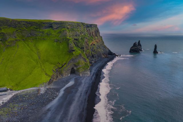
Yes. The basalt columns and the sea stacks remain intact and continue to define the landscape.