
We use cookies to enhance your browsing experience, serve personalized content, and analyze our traffic. By clicking "Accept All" you accept this and consent that we share this information with third parties and that your data may be processed in the USA. For more information, please read our .
You can adjust your preferences at any time. If you deny, we will use only the essential cookies and unfortunately, you will not receive any personalized content.

If you live in the northern United States and have been hoping to see the northern lights without booking a flight to Iceland, this weekend may be your chance. NOAA says a fast-moving stream of solar wind has already triggered geomagnetic storm conditions, and the effects could continue through Monday, March 16.
Conditions are lining up well for viewing. The moon will be relatively cooperative, and March is historically one of the best months of the year for aurora viewing in the lower 48. If the skies stay clear, many people across the northern states could have a real shot at seeing the lights. Here’s what to know before you head outside tonight.
Good news for skywatchers across the northern United States: the northern lights may make an appearance this weekend, and the conditions needed to trigger them are already underway. A fast-moving stream of solar wind pushed Earth into geomagnetic storm conditions overnight, with NOAA reporting a moderate (G2) storm level. Scientists expect the disturbance to linger through Monday, March 16, creating a window when the aurora could dip far enough south to be visible in parts of the northern U.S.
The activity is being driven by something called a coronal hole, which is essentially a gap in the sun’s outer atmosphere. The sun constantly releases charged particles into space in a steady flow known as the solar wind. Most of the time that wind moves at a fairly steady pace. But when Earth passes through a coronal hole, the particles streaming out arrive faster and with much more energy.
A simple way to picture it is the difference between a garden hose running at low pressure and one suddenly turned all the way up. The stream hitting Earth right now is the high-pressure version.
According to NOAA’s latest forecast discussion, solar wind speeds climbed to around 700 kilometers per second over the past day. Normal speeds are usually closer to 400 to 500 kilometers per second, so what reached Earth overnight was significantly stronger than usual.
When a surge like that hits Earth, it pushes against the planet’s magnetic field, compressing and disturbing it. That disturbance is what scientists call a geomagnetic storm, and it is exactly the kind of event that allows the aurora to spread farther south than usual. A G2-level storm can bring the northern lights well beyond Alaska and Canada if skies stay clear.
Source: Screenshot from NOAA website, March 14
According to NOAA’s aurora viewline, the northern lights could be visible across parts of the northern United States this weekend, usually low on the northern horizon. The best chances are in states closest to Canada, including Alaska, plus northern parts of Washington, Idaho, Montana, North Dakota, South Dakota, Minnesota, Wisconsin, Michigan, and Maine.
A few things help explain what that actually means:
“Visible” usually means low on the northern horizon. Unless you are far north (like Alaska), the lights will likely appear near the horizon rather than directly overhead. The farther south you are within a state, the fainter the display may be.
Clear skies matter more than anything else. Even a strong geomagnetic storm is invisible through clouds. Meanwhile, a moderate storm with perfectly clear skies can still produce a beautiful display.
Light pollution makes a big difference. City lights can wash out the aurora. Driving 20 to 30 miles away from major urban areas can dramatically improve what you see.
In short, the darker your sky and the clearer your horizon to the north, the better your chances.
One helpful note from NOAA’s latest forecast: the solar wind conditions driving this event are expected to continue through March 16 because Earth is still passing through a fast stream of particles from the sun. In practical terms, that means this isn’t just a one-night opportunity. If skies are cloudy where you live tonight, Sunday and Monday nights are also worth watching as the activity continues.
There is also a seasonal reason March tends to produce good aurora displays. We are approaching the spring equinox on March 20, and this time of year historically sees more frequent northern lights activity. Around the spring and autumn equinoxes, the orientation of Earth’s magnetic field makes it easier for energy from the solar wind to slip into the atmosphere and trigger auroras.
The easiest way to picture it is that Earth’s magnetic shield becomes a little easier to “push open” during March and September. Because of that seasonal boost, any solar activity over the next couple of weeks has a better-than-average chance of producing visible northern lights if skies cooperate.
Knowing the forecast is only part of it. Here is the practical checklist:
Check conditions within an hour of going out. Space weather can shift significantly in a short window. Use NOAA's 30-minute aurora forecast at swpc.noaa.gov or apps like My Aurora Forecast, SpaceWeatherLive, or Aurora Now for live data.
Watch the Bz number. When it is negative and sustained below minus 5, conditions are active. When it swings back to positive, activity quiets down.
Get away from light pollution. Use a light pollution map like lightpollutionmap.info to find dark sky locations near you. Even a short drive makes a real difference.
Face north and be patient. The aurora often starts as a faint greenish glow low on the horizon before building. Give your eyes at least 20 minutes to adjust to the dark.
Earlier in the evening is better tonight. A waning gibbous moon will rise in the early hours of Sunday, making conditions ideal for a dark night sky earlier in the evening. Get out before midnight for the darkest window.
Source: Screenshot from NOAA website, March 14
You don’t need a fancy camera to capture the northern lights. Most modern smartphones handle low-light surprisingly well if you give them the right conditions. If your phone has Night Mode or Pro Mode, turn it on and use the main camera lens rather than the ultra-wide for sharper photos. The biggest trick is keeping the phone completely still. A small tripod works great, but even resting your phone on a rock, fence, or car roof can work.
Expect the camera to take longer exposures of about five to ten seconds. If your phone allows it, shooting in RAW format can give you more flexibility if you edit the photo later. One thing that surprises people: your camera often sees more color than your eyes do. What looks like a faint grayish glow in the sky might show up as green, purple, or even red in a photo. So it’s always worth taking a few shots, even if the display looks subtle at first.
And this weekend, the conditions aren’t just theoretical. The solar wind is already elevated and the geomagnetic storm is already underway. At this point, the biggest question is simple: will the sky above you cooperate?
NOAA's forecast puts the aurora viewline across Alaska, Washington, Idaho, Montana, North Dakota, South Dakota, Minnesota, Wisconsin, Michigan, and Maine. The display will most likely appear low on the northern horizon from these states. Clear, dark skies are essential for any chance of seeing it.
NOAA's technical forecast shows enhanced solar wind conditions continuing through at least March 16 due to the ongoing coronal hole high-speed stream. Sunday and Monday nights are also worth watching if tonight is cloudy.
The Bz is the north-south direction of the magnetic field carried by the solar wind. When it points south and stays below minus 5 nT, it opens a connection between the solar wind and Earth's atmosphere that triggers aurora. Overnight it reached minus 10 nT, which is solidly favorable. Check it in real time on SpaceWeatherLive or NOAA's forecast tools.
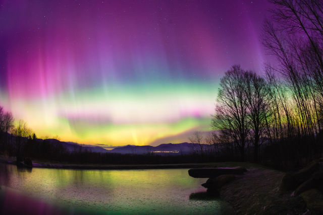
NOAA rates geomagnetic storms on a scale of G1 to G5. A G2, or moderate storm, is enough to push the visible aurora down into the northern US states on a clear night. Overnight conditions reached G2 level. A G5 would push aurora as far south as Florida, but those are rare events.
March is statistically one of the best months for aurora because of the Russell-McPherron effect, which causes Earth's magnetic field to align more favorably with the solar wind around the spring equinox. This makes geomagnetic storms more likely and more intense in March and September than at other times of year.
My Aurora Forecast, SpaceWeatherLive, Aurora Now, and Glendale Aurora all provide live solar wind data and real-time Kp and Bz readings. NOAA's Space Weather Prediction Center at swpc.noaa.gov also offers a 30-minute aurora viewline forecast that updates continuously.
Possibly, during a strong geomagnetic storm. This weekend's G1 to G2 activity primarily favors states near the Canadian border. If activity strengthens to G3 or higher, the viewline would push further south. Keep an eye on the Kp index: a Kp of 6 or above starts to bring aurora into the central US states.
No. Modern smartphones with Night Mode or Pro Mode work well. Use your main lens, stabilize the phone on a flat surface or tripod, shoot in RAW if available, and expect exposures of five to ten seconds. The camera often picks up significantly more color than the naked eye sees during a moderate display.