We use cookies to enhance your browsing experience, serve personalized content, and analyze our traffic. By clicking "Accept All" you accept this and consent that we share this information with third parties and that your data may be processed in the USA. For more information, please read our .
You can adjust your preferences at any time. If you deny, we will use only the essential cookies and unfortunately, you will not receive any personalized content.

NOAA says a potentially historic El Niño is strengthening ahead of winter 2026-27, and travelers across the U.S. could feel the effects. Forecasters now give the event a greater than 90% chance of becoming very strong, with a 75% chance it could exceed the strength of previous El Niños in records dating to 1950. The effects won't look the same everywhere, with wetter conditions favored across much of the southern U.S. while parts of the North could see a milder, drier winter. California is already preparing for possible flooding, landslides, heavy mountain snow, and transportation disruptions. Here's what travelers should know before planning winter road trips, flights, ski vacations, and warm-weather getaways.
NOAA gives El Niño a greater than 90% chance of becoming very strong during fall and winter 2026-27.
There is a separate 75% chance it reaches historic strength, exceeding previous El Niño events in NOAA's record dating to 1950.
"Super El Niño" is an informal term, not an official NOAA category, generally used to describe an exceptionally strong event.
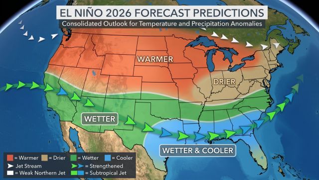
NOAA's latest outlook favors wetter-than-normal conditions across much of the southern and central U.S., including parts of California, the Southwest, Gulf Coast, Southeast, and Mid-Atlantic.
El Niño winters generally bring less storminess and milder conditions across parts of the northern U.S.
The strongest U.S. impacts from El Niño typically become more noticeable during the winter months.

You need to agree with the cookies and privacy policy of this external service to view the content
El Niño is a natural climate pattern caused by unusually warm waters in the tropical Pacific, which can shift the jet stream and weather patterns around the world. This year's event, however, is strengthening rapidly.
NOAA's Climate Prediction Center says there is now a greater than 90% chance of a very strong El Niño this fall and winter. During October through December, NOAA also gives it a 75% chance of becoming stronger than previous El Niño events in its record dating to 1950.
Recent weekly measurements have already crossed the temperature threshold commonly associated with a "super" El Niño, although NOAA officially measures El Niño strength using longer three-month averages. Live Science reports that eastern Pacific sea-surface temperatures recently reached 2.1°C above average, while The Weather Channel notes that NOAA's official three-month measurements have not yet reached record levels.
In other words, this could become an exceptionally strong El Niño, but "historic" doesn't automatically mean every part of the country will experience historic weather.
NOAA's Climate Prediction Center says El Niño has a greater than 90% chance of becoming very strong during fall and winter 2026-27. Source: NWS Climate Prediction Center via X, Sept. 10, 2026:
El Niño tends to push the main winter storm track farther south across the United States. That generally means wetter and stormier conditions across the southern tier, while northern states often experience fewer storms and milder temperatures.
NOAA's September seasonal outlook favors above-normal precipitation from Southern California through much of the Four Corners and Great Plains, across the Mississippi and Tennessee valleys, the Southeast, and into the Mid-Atlantic. The strongest early-season wet signal is currently along parts of the Gulf Coast and Southeast.
For travelers, that could mean very different winter concerns depending on where you're headed:
California and the Southwest: Heavy rain, mountain snow, flooding, landslides, and road closures could complicate road trips and ski travel during individual storms.
Texas, the Gulf Coast, and Southeast: A more active southern storm track could bring wetter conditions, heavy rain, and occasional severe weather.
Mid-Atlantic and parts of the East Coast: A wetter pattern could mean more winter storms, although whether precipitation falls as rain or snow will depend on temperatures during each individual system.
Northern U.S. and parts of the Northwest: El Niño typically favors a milder and less stormy winter, although that certainly doesn't eliminate the possibility of major snowstorms or cold snaps.
Seasonal outlooks show what conditions are more likely over several months, not what the weather will be during a particular vacation.
Typical El Niño winters favor wetter and cooler conditions across much of the southern U.S., while parts of the northern tier tend to be warmer. Individual winters can vary considerably. Image: NOAA Climate.gov / Climate Prediction Center.a
California is taking the threat seriously enough that Governor Gavin Newsom declared a statewide state of emergency on September 21 to prepare for the approaching El Niño winter.
The order directs state agencies to prepare for flooding, landslides, debris flows, coastal flooding, heavy snow, and transportation disruptions. Caltrans has also been directed to stage traffic-control, road-closure, and snow-removal equipment along vulnerable highways before severe storms arrive.
That doesn't mean California is expecting roads to close all winter. But anyone planning a drive along Highway 1, crossing Sierra Nevada passes, or visiting mountain resorts should check Caltrans QuickMap before traveling during active storms.
Recent wildfire burn scars are another concern. Burned hillsides can produce flash flooding and debris flows with much less rainfall than normally required, potentially affecting roads near recently burned mountain and canyon areas.
California is preparing for possible heavy rain, coastal impacts, flooding and landslides as El Niño strengthens ahead of winter.
You don't have to be driving through a flood zone to have an El Niño winter affect your trip. A more active southern storm track can create ripple effects through airports, highways, mountain passes, and airline networks around the country. Heavy rain, snow, wind, and low visibility can slow flights even when airports remain open. A storm affecting California, Dallas, Atlanta, or another major hub can also disrupt aircraft and crews headed to completely different destinations.
Ski travelers have an additional complication. A wetter winter can mean substantial snowfall in some areas when temperatures cooperate, but the same storms that improve mountain conditions can also trigger chain controls, highway closures, flight delays, and difficult driving.
The smartest approach isn't avoiding winter travel altogether. It's leaving a little more flexibility around important connections and checking the actual forecast as your trip gets closer
El Niño can increase precipitation across parts of the southern U.S., but mountain travelers will still need to watch individual forecasts for snow, chain controls and difficult driving conditions.
A Super El Niño is a seasonal climate pattern, not a months-long weather forecast. It can tell scientists which types of conditions are becoming more likely, but it can't tell you whether it will rain in Los Angeles during your January vacation or snow on the day you're flying into Denver.
Heavy rain, wind and winter storms can cause flight delays even when airports remain open, with disruptions sometimes rippling through airline networks.
NOAA specifically cautions that even with an El Niño this strong, the typical impacts are more likely, not guaranteed.
For travelers, that means the most useful information will still come from short-range forecasts in the days before departure. Check airport conditions, road closures, National Weather Service alerts, and mountain forecasts as your trip approaches, particularly when traveling through areas expected to have an active storm pattern.
El Niño is officially underway and strengthening. "Super El Niño" isn't an official NOAA classification, but weekly Pacific temperatures have crossed a threshold commonly associated with the term. NOAA currently says there is a greater than 90% chance the event becomes very strong this fall and winter.
Possibly. NOAA currently gives the event a 75% chance of exceeding previous El Niño events in its record dating to 1950, but that has not happened officially yet.
No. The typical pattern favors a stronger southern storm track and wetter conditions across much of the southern U.S., while parts of the northern U.S. tend to be milder and less stormy.
Not necessarily. El Niño can increase precipitation in some areas, but temperatures determine whether that falls as rain, snow, or a mix. Some ski destinations could benefit from major snowstorms while others may see warmer systems.
No. California remains perfectly reasonable to visit, but travelers should pay closer attention to weather forecasts during active storms, particularly when driving coastal highways, crossing mountain passes, or visiting recent wildfire areas.
El Niño's influence on U.S. weather generally becomes more established during winter, with the typical impacts becoming more widespread from roughly December through March.